


Deskripsi Locus Map Free - Outdoor GPS navigation and maps
Navigation with offline maps for fully enjoyable outdoor experience. Create, plan, edit, record, save or share your trips, keep the memories, track your performance and much more. Locus Map is designed for hiking, mountain biking, cycling, running, geocaching, cross-country skiing and other outdoor activities. Find a range of cool functions running above variety of maps of the whole World:
Hiking, cycling and other sports:
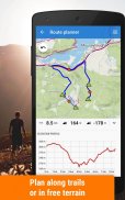
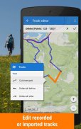
Routes and interesting places:
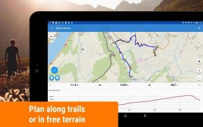
• plan your routes along hiking trails, bike trails or in open field
• record your tracks with all useful statistics – distance, speed, tempo, altitude, calorie burn and more
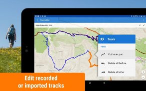
• import and export the routes in different formats (KMZ, GPX, TCX...)
• share your tracks on Strava, Runkeeper, GPSies or Google Earth
• create own database of interesting or favorite places
• display photos on the map
• import and export POIs (points of interest) in various formats
• find detail information about track points or important places
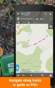
Offline navigation and guidance:
• sound and voice navigation working offline adjustable for hiking, cycling or a car
• sound alert when missing the route
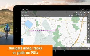
• navigation along routes imported from elsewhere
• on point guidance in open field
• sound notification of an upcoming point of interest
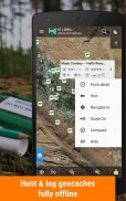
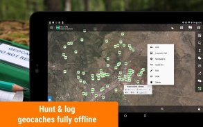
Geocaching:
• geocaches download for offline geocaching
• on-cache navigation above the map or using the compass
• online and offline logging, graphical and calculation tools
• field notes management
• sound alert of an upcoming geocache
Other handy functions:
• audio coach – sports tracker with voice information about your performance
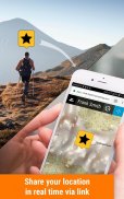
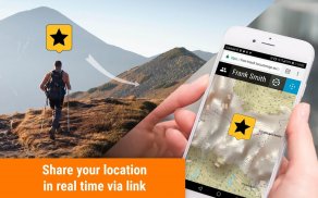
• live tracking – share your location in real time
• smart GPS – saving the battery of your mobile device
• parking assistant – finds your car in the crowded parking lot
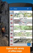
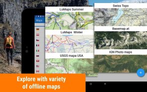
Select from a wide portfolio of maps:
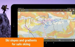
• LoMaps - offline maps of all the World - switch them to hiking/biking map, winter or city map. FREE DOWNLOAD of the first 3 LoMaps.
Detailed hiking maps and cycling maps of the best world map publishers:
• Great Britain by Ordnance Survey (Explorer, Landranger),
• USA by USGS classic/satellite, NeoTreks (AccuTerra),
• Canada by BackRoad Map Books,
• maps of Switzerland by SwissTopo, Belgium by IGN Belgium, France by IGN France, Denmark by Kortforsyningen, Iceland by LMI Atlas Map, Netherlands by Map5.nl, Slovenia by PZS Maps, Spain by CNIG maps, Sweden by Lantmäteriet, Poland by Compass, Germany, Austria and North Italy by Kompass, Outdooractive – Summer and Winter maps, Basemap.at and Freytag-Berndt, Czechia and Slovakia by SHOCart and Geodézie Online
and many others...
• support of external maps in SQLite, TAR, MBT, GEMF, Orux or RMA formats, and of own OpenStreetMap or map themes
App uses the Device Administrator permission.
Locus Map Free is highly customizable. You can set everything according to your needs!
Do you want Locus Map to handle even more functions with no limits? For example bike computer with full support of external bluetooth and ANT+ sensors? Then download Locus Map Pro!
Homepage:
https://www.locusmap.eu
Help desk:
http://help.locusmap.eu
Manual:
http://docs.locusmap.eu
Navigasi dengan peta offline untuk pengalaman luar ruangan yang menyenangkan. Buat, rencanakan, edit, rekam, simpan atau bagikan perjalanan Anda, simpan kenangan, lacak kinerja Anda, dan banyak lagi. Locus Map dirancang untuk hiking, bersepeda gunung, bersepeda, berlari, geocaching, ski lintas alam dan kegiatan luar ruangan lainnya. Temukan berbagai fungsi keren yang berjalan di atas berbagai peta dari seluruh Dunia:
Hiking, bersepeda, dan olahraga lainnya:
Rute dan tempat menarik:
• rencanakan rute Anda di sepanjang jalur hiking, jalur sepeda atau di lapangan terbuka
• rekam jejak Anda dengan semua statistik yang berguna - jarak, kecepatan, tempo, ketinggian, pembakaran kalori, dan lainnya
• mengimpor dan mengekspor rute dalam berbagai format (KMZ, GPX, TCX ...)
• bagikan jejak Anda di Strava, Runkeeper, GPSies, atau Google Earth
• buat basis data sendiri dari tempat menarik atau favorit
• menampilkan foto di peta
• impor dan ekspor POI (tempat menarik) dalam berbagai format
• temukan informasi detail tentang titik-titik lintasan atau tempat-tempat penting
Navigasi dan panduan luring:
• navigasi suara dan suara bekerja offline disesuaikan untuk hiking, bersepeda atau mobil
• peringatan suara ketika melewatkan rute
• navigasi sepanjang rute yang diimpor dari tempat lain
• tentang bimbingan titik di bidang terbuka
• pemberitahuan suara dari suatu titik tujuan yang akan datang
Geocaching:
• unduhan geocaches untuk geocaching offline
• navigasi di-cache di atas peta atau menggunakan kompas
• online dan log offline , alat grafik dan perhitungan
• manajemen catatan lapangan
• peringatan suara dari geocache yang akan datang
Fungsi berguna lainnya:
• pelatih audio - pelacak olahraga dengan informasi suara tentang kinerja Anda
• pelacakan langsung - bagikan lokasi Anda dalam waktu nyata
• GPS pintar - menghemat baterai perangkat seluler Anda
• asisten parkir - menemukan mobil Anda di tempat parkir yang padat
Pilih dari portofolio peta yang luas:
• LoMaps - peta offline dari semua Dunia - alihkan mereka ke peta hiking / bersepeda, musim dingin atau peta kota. Unduhan GRATIS dari 3 LoMaps pertama.
Rinci peta hiking dan peta bersepeda dari penerbit peta dunia terbaik:
• Britania Raya oleh Ordnance Survey (Penjelajah, Landranger),
• USA oleh USGS klasik / satelit, NeoTreks (AccuTerra),
• Kanada oleh BackRoad Map Books,
• peta Swiss oleh SwissTopo, Belgia oleh IGN Belgia, Prancis oleh IGN Prancis, Denmark oleh Kortforsyningen, < b> Islandia oleh LMI Atlas Map, Belanda oleh Map5.nl, Slovenia oleh PZS Maps, Spanyol oleh peta CNIG, < b> Swedia oleh Lantmäteriet, Poland oleh Kompas, Jerman, Austria, dan Italia Utara oleh Kompas, Outdoor - Peta Musim Panas dan Musim Dingin, Basemap.at dan Freytag- Berndt, Czechia dan Slovakia oleh SHOCart dan Geodézie Online
dan banyak lagi...
• dukungan peta eksternal dalam format SQLite, TAR, MBT, GEMF, Orux atau RMA, dan dari OpenStreetMap atau tema peta sendiri
Aplikasi menggunakan izin Administrator Perangkat.
Locus Map Free sangat dapat disesuaikan . Anda dapat mengatur semuanya sesuai dengan kebutuhan Anda!
Apakah Anda ingin Locus Map menangani bahkan lebih banyak fungsi tanpa batas? Misalnya komputer sepeda dengan dukungan penuh dari bluetooth eksternal dan sensor ANT +? Kemudian unduh Locus Map Pro!
Homepage:
https://www.locusmap.eu
Meja bantuan:
http://help.locusmap.eu
Manual:
http://docs.locusmap.eu
Locus Map Free - Outdoor GPS navigation and maps - Versi 4.21.1
(25-01-2024)

Locus Map Free - Outdoor GPS navigation and maps - Informasi APK
Versi APK: 4.21.1Paket: menion.android.locusVersi Terakhir dari Locus Map Free - Outdoor GPS navigation and maps
Aplikasi pada kategori yang sama
Anda juga mungkin suka...


